Results
Modern fire activity
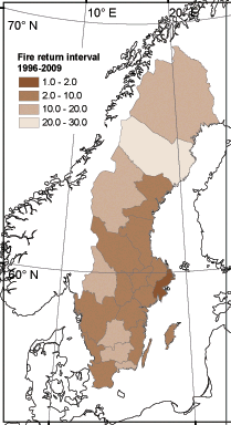
Forest fire activity in Sweden changed dramatically over the course of 19th and 20th centuries (Fig. below, note that the numbers are in 103 years). The major trend was a gradual decrease in the level of fire activity, particularly evident while considering large fire years. Increasingly effective fire suppression policy is the primary reason for this dynamics. Typical fire cycle in northern part of Sweden varied between 10 *103 to 20*103 years, with somewhat shorter cycles being common in the southern part of the country (103 to 10*103 years).
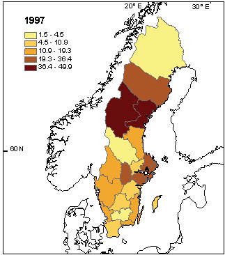
Presently, total annual forest area burned in Sweden is dominated by single relatively large fires which contribute to the most of the area burned in a county (län). Figure below shows percentage of area burned in 1997, in relationship to the total area burned in respective county over 1996-2008.
Historic fire activity
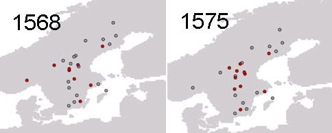
We study historical fire regimes using an unique network of fire history sites distributed over the whole Sweden with the reconstructions stretching over 400-1000 years. Below is an example of two large fire years in Sweden during 1500es. Red points refer to sites where the year in question was recorded as a fire year. Grey points refer to sites, which recorded no fires at that year. Both presented years were geographically associated with the area of Götaland, which exemplifies sub-regional pattern of fire activity in Sweden.
An important feature of Scandinavian historic fire regimes is rather onset of fire supression policies during 1700-1800es and disappearance of fire as one of the main disturbance factors in the forests. Below is an example of onset of fire supression period in the Norra Kvill national park, Southern Sweden (Niklasson & Drakenberg 2001, Biological Conservation).
.
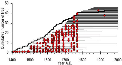
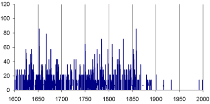
Pattern gradual disappearance of fire is also visible in the temporal pattern of the absolute number of scars in collected pine samples (data from a subset of 39 sites with the longest temporal coverage).
Dendrochronological reconstruction of summer drought indexes
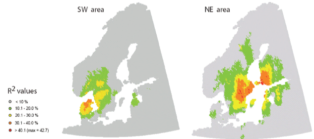
As a part of the existing project we reconstructed temperal dynamics of growth season drought index (Prentice et al 1993) over 1750-2000 (Drobyshev et al. 2011). Analysis of correlation maps indicated regional differences in the DI dynamics (see figure below). The SW and NE reconstructions reflected two different climate regimes associated with the Kattegat area (SW reconstruction) and southeastern Swedish coast of the Baltic sea (NE reconstruction) (see Figure below). The analysis indicated predictive power of both reconstructions outside the sampled area. Surprisingly, the highest predictive power of the SW reconstruction (R2 above 30%) was observed over the territory of central and northern Denmark, limited by 56.0 and 57.4°N. A zone with moderate predictive power (R2 = 20–30%) stretched over the central part of Denmark in the southwest direction from sampled area (down to 55.6°N), and up to 59°N in the northeast direction.
Climatic variability and fire activity
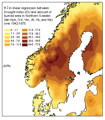
Strong coupling exists between modern fire activity and climatic variability represented by fire weather indexes. In an example below we show predictive power of Drought Index (DI, Prentice t al. 1993) in respect to annual total area burned in Norrland (counties of Kpb, Gvl, Vnr, Jtl, Vb, Nb) over 1942-1975. Even if modern levels of forest fire activity in Sweden are very low from historical perspective, there is a strong spaciotemporal association between fire activity and climatic variability at regional scales, which provides ground for modeling of the future fire hazard.
… more results coming soon …

